Research
My research has covered a wide range of atmospheric phenomena, including severe weather, hurricanes, cyclones, and the jet stream. My expertise is quantifying model uncertainty using objective statistical tools. These tools have included ensemble sensitivity analysis, empirical orthogonal functions (EOFs), bootstrap resampling, and multivariate regressions. Additionally, I have incorporated various visualization techniques, such as trajectory analysis, vertical cross sections, and spatial weather maps.
Midlatitude Jet Stream Predictability
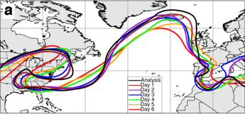
Motivation: Model prediction of the jet stream is often associated with variability in position and amplitude (left Figure below). Previous studies have suggested upstream cyclones may play a role in modulating jet stream prediction.
Research Question: How can we decompose jet stream modes of variability and how correlated is jet stream prediction to cyclone development?
Methodology:
Key Finding: Jet stream amplitude variability is strongly correlated to the cyclone's intensity and related moisture transport. Therefore, improved representation of the U.S. cyclone could lead to an improved forecast of the jet stream over the North Atlantic and associated European weather.
Research Question: How can we decompose jet stream modes of variability and how correlated is jet stream prediction to cyclone development?
Methodology:
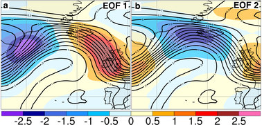
- I used ECMWF ensemble model forecasts of the North Atlantic jet stream and isolated forecast variability using EOF analysis (middle Figure below).
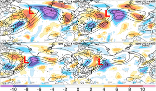
- I then used ensemble sensitivity analysis to relate EOF 2 (representing amplitude variability) to an upstream cyclone over the U.S. (right Figure below).
Key Finding: Jet stream amplitude variability is strongly correlated to the cyclone's intensity and related moisture transport. Therefore, improved representation of the U.S. cyclone could lead to an improved forecast of the jet stream over the North Atlantic and associated European weather.
Model forecasts can be characterized by large forecast variability
|
Isolate modes of forecast variability
using EOF analysis |
Key Finding: Model errors over Europe can be traced to Northeast U.S. Cyclones
|
Severe Weather ForecastingMotivation: Models often do not predict severe weather well. For example, the right Figure shows predicted reflectivity over Nebraska and South Dakota for: the observed field (row 1); ensemble member 1's field (row 2); and ensemble member 4's field (row 3). Member 4 does not accurately predict storms over northern South Dakota, but both members 4 and 1 develop storms four hours too early compared to reality.
Research Question: Why do some models predict storms correctly but others do not? Methodology: I created a 50 member ensemble of the Weather Research and Forecasting (WRF) model with varying initial conditions to quantify how these small initial condition variations influence thunderstorm prediction over Nebraska and South Dakota. Afterwards, I used ensemble sensitivity analysis to diagnose why some members had storms but others did not. Key Finding: Members that predicted thunderstorms had a faster upstream upper-level trough over Utah than members that did not predict thunderstorms. Therefore, improved prediction of upper-level troughs over Utah could lead to a better forecast of thunderstorms over the Midwest. In other words, differences in model prediction of thunderstorms could be due to differences in the position of upstream upper-level troughs. |
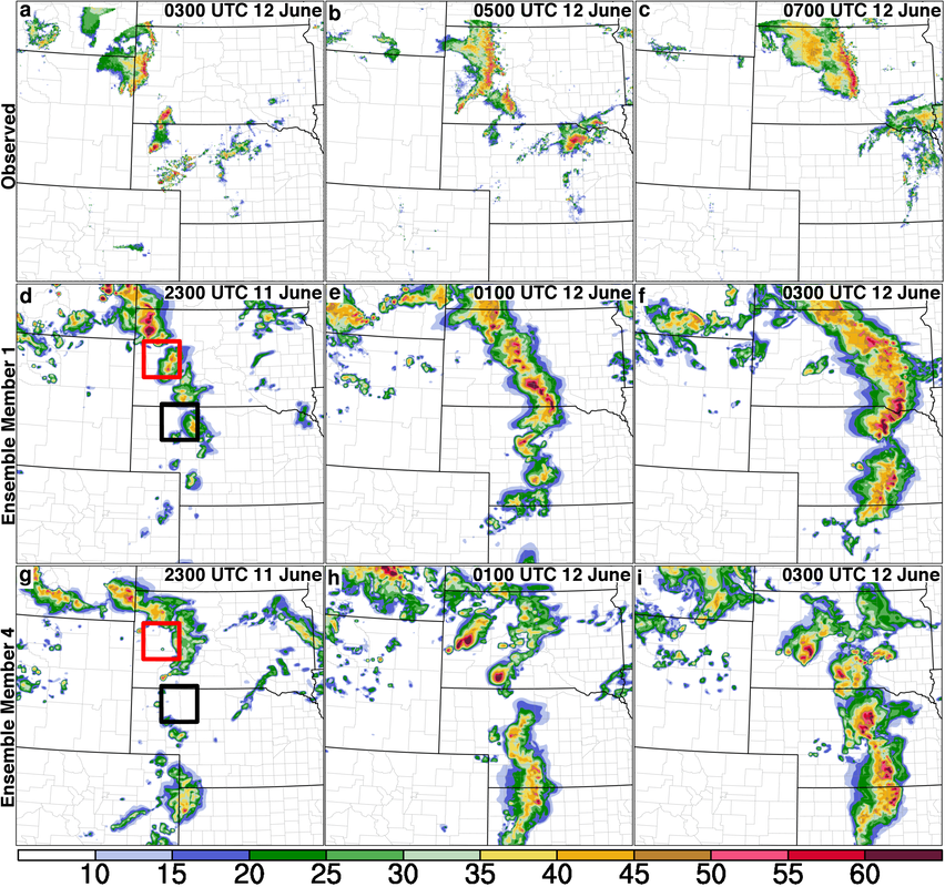
Reflectivity over the Midwest of (a)-(c) observed reflectivity, (d)-(f) forecasted reflectivity of ensemble member 1, (g)-(i) forecasted reflectivity of ensemble member 4. [Courtesy of AMS Journal Article Berman et al. (2017)]
|
Tropical Cyclone (Hurricane) Prediction
Motivation: Tropical Cyclone (TC) intensity prediction has not improved much over the last decade. One potential reason is that models do not predict well how dry air impacts TC development. Since under-predicted TC intensity can create dangerous situations, it is imperative to understand how much impact dry air has on TC development.
Research Question: How does the amount of dry air impact the development time of a TC?
Methodology: Created 11 idealized sets of 20-member ensembles utilizing varying moisture profiles to see how long it took them to develop a TC with > 50 m/s max 10-m winds (see Figure below).
Key Finding: TC spin-up time (time > 50 m/s max 10-m winds) increases for simulations with drier air (see (a) below). Therefore, improved prediction of lower-tropospheric moisture content near a TC can lead to improved prediction of TC intensification, which in turn can better prepare people for TC hazards such as heavy precipitation or storm surge.
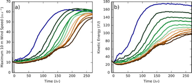
Time series of the ensemble-mean (a) 10-m maximum wind speed (m/s) and (b) Integrated Kinetic Energy (PJ) for each experimental set. Colors for each set represent forecasts with 0%, 10%, 20%, ... 90% reduction in moisture content. [Image from AMS Journal Article: Tang et al. (2016)]
